Using Mapbox GL JS
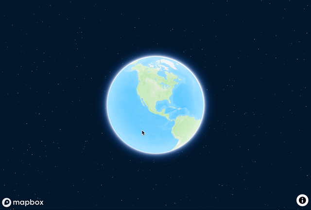
Your gateway to Mapbox GL JS v3 in R is the mapboxgl()
function. Run the function with no arguments to get an interactive globe
using Mapbox’s Standard style:
To use Mapbox maps, you will need a Mapbox
access token. If you are a user of the mapboxapi package and have
installed your Mapbox access token, mapboxgl() will pick up
your token for you. If you are new to my R packages, you’ll want to get
a token from your Mapbox account, run
usethis::edit_r_environ(), and set the environment variable
MAPBOX_PUBLIC_TOKEN="your_token_here". It’s important for
you to know that Mapbox GL JS is a commercial product that charges you
for map views; however, it does have a generous free tier.
Mapbox’s default styles are accessible with the
mapbox_style() function, and can be passed to the
style parameter to change the style of your map. Mapbox GL
JS also supports modifying map projections; here we use
projection = "winkelTripel" for the Winkel Tripel global
projection.
mapboxgl(
  style = mapbox_style("satellite"),
  projection = "winkelTripel")
To get a more local view in your map, you can use the
center, zoom, pitch, and
bearing arguments. In the example shown below, these
arguments are incorporated into a “fly to” animation.
mapgl supports several of these animated transitions.
In Mapbox GL JS v3, the new Standard style includes custom-rendered
buildings around the world, such as the American Airlines Center in
Dallas.
mapboxgl(
  center = c(-97.6, 25.4)
) |>
  fly_to(
    center = c(-96.810481, 32.790869),
    zoom = 18.4,
    pitch = 75,
    bearing = 136.8
  )
Using Maplibre GL JS
Maplibre GL JS, a fork of the more permissively-licensed Mapbox GL JS
1.0, is also available to R users in mapgl. The core
function to initialize a MapLibre map is maplibre(). The
default tiles in maplibre() are CARTO’s Voyager tiles,
which are usable without an API key.
MapTiler tiles are also
available via the maptiler_style() function. These styles
work quite well with MapLibre, but do require an API key; set the
environment variable MAPTILER_API_KEY in your .Renviron
file to store your key. The example below uses the Bright MapTiler
style, and adds a fullscreen control and a navigation control to the
map.
These controls and styles are available with mapboxgl()
as well; mapgl aims to provide a consistent API to work
with either Mapbox or MapLibre.
maplibre(
  style = maptiler_style("bright"),
  center = c(-43.23412, -22.91370),
  zoom = 14
) |>
  add_fullscreen_control(position = "top-left") |>
  add_navigation_control()
Quick data visualization with view functions
If you’re looking to quickly visualize spatial data without building
layers from scratch, mapgl includes view functions that
streamline the process. mapboxgl_view() and
maplibre_view() automatically detect your data type and
create appropriate visualizations with sensible defaults.
These functions work with sf objects and terra rasters, and will automatically style your data based on geometry type. You can also specify a column for styling, and the functions will create appropriate color scales for you.
## Linking to GEOS 3.13.0, GDAL 3.8.5, PROJ 9.5.1; sf_use_s2() is TRUE
# Quick view of the North Carolina dataset
nc <- st_read(system.file("shape/nc.shp", package="sf"))
## Reading layer `nc' from data source
## `/Library/Frameworks/R.framework/Versions/4.6/Resources/library/sf/shape/nc.shp'
## using driver `ESRI Shapefile'
## Simple feature collection with 100 features and 14 fields
## Geometry type: MULTIPOLYGON
## Dimension: XY
## Bounding box: xmin: -84.32385 ymin: 33.88199 xmax: -75.45698 ymax: 36.58965
## Geodetic CRS: NAD27
maplibre_view(nc, column = "AREA")If you want to add additional layers on top of a view function, you
can use the add_view() function to stack layers. This gives
you a middle ground between the quick view functions and the full
layer-by-layer approach shown in the layers
overview vignette.
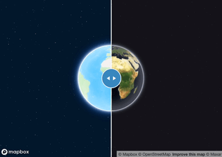
Comparing map views
mapgl includes a function compare()
that allows users to create synced swipe maps that can compare two
styles. This function works for either Mapbox or MapLibre maps.
m1 <- mapboxgl()
m2 <- mapboxgl(mapbox_style("satellite-streets"))

compare(m1, m2)